gipfel - photogrammetry for mountain images
Screenshot

The screenshot shows the view from Lempersberg to Zugspitze in the Bavarian alps.
The GPS data comes from Jonathan de Ferranti's great website
http://www.viewfinderpanoramas.org/.
Description
gipfel helps to find the names of mountains or points of interest
on a picture.
It uses a database containing names and GPS data. With the given viewpoint
(the point from which the picture was taken) and two known mountains
on the picture, gipfel can compute all parameters needed to compute the
positions of other mountains on the picture.
gipfel can also be used to play around with the parameters manually.
But it's pretty difficult to find the right parameters for a given
picture manually.
You can think of gipfel as a georeferencing software for arbitrary images
(not only satellite images or maps).
gipfel also has an image stitching mode, which allows to generate panorama
images from multiple images that have been referenced with gipfel.
The nice thing about the new image stitching is that it reuses the
code that already existed for referencing images.
Download
Source:
gipfel-0.4.1.tar.gz
sha256 a48a3e9b555749d04d82a016a0633203109ea561b03849827ff70b0c2119794d
pkgsrc:
A pkgsrc package is also available.
Source Repository
A git repository can be found here.
Requirements
- fltk-1.3.x
- libtiff
- libjpeg
- exiv2
- GSL - GNU Scientific Library
- gipfel works on UNIX-like systems (e.g. Linux, *BSD, Solaris), Mac OS X, and Windows (using MinGW). There is a precompiled Windows binary package (see Download).
Changes from 0.4.0 to 0.4.1
- fix compilation with newer Exiv2 library
- fix compilation on NetBSD - by Thomas Klausner
Video
Here is an (old) video (6MB) that demonstrates how
gipfel works. Streaming does currently not work, so you may need to
download the file first.
A picture by Carsten Clasohm (http://www.clasohm.com/)
taken from Simmetsberg towards Benediktenwand is used.
First the current viewpoint is set.
Then some peaks are marked by positioning the green flags.
After that, the one known peak (Benediktenwand) is marked with a red flag.
After that the "guess" button is
pushed and gipfel computes the positions of the other peaks.
Now, a GPS-track from http://www.alpin-koordinaten.de is loaded. It shows a nice
hike to Jochberg.
Finally the effect of the various view parameters is shown by modifying them
manually.
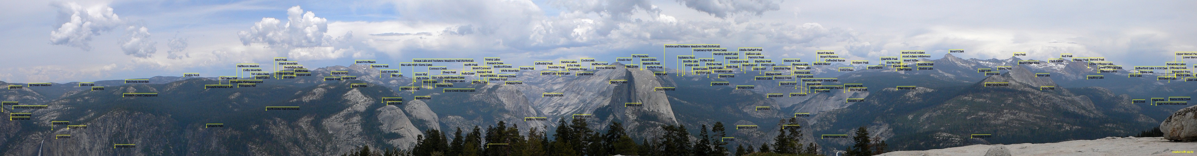
Panorama Images
The following images are stitched together with the gipfel stitching option.
for i in *.jpg; do gipfel -s -b -t tiff/$i $i; donewas used to create correctly oriented tiff images.
These tiff images were then blended using enblend.


The following one is from Sentinel Dome (Yosemite) with
USGS data: